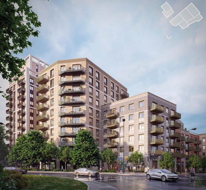
At the weekend, proposals were exhibited for a redevelopment of the former Reading police station with a residential led project of 205 build-to-rent apartments. I went along and asked a few questions, so read on for some further details, images of the proposals and a link to the developer’s feedback survey.
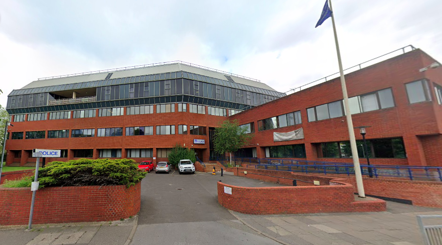
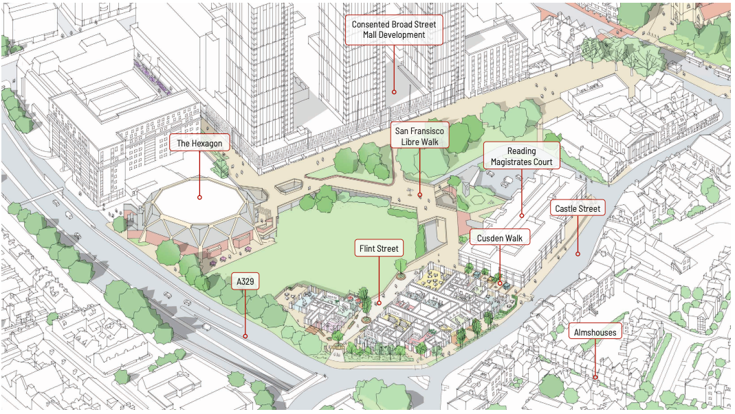
The police have relocated from their 1976 HQ, after considerable delay, to a new base to the south of town near the stadium, freeing up a highly prominent corner plot at the junction of Castle Street and the IDR. Thankfully the site does not seem set to lie derelict for too long with the proposed redevelopment due to be submitted for planning in the coming weeks. It could have been sooner, with the developer at the exhibition explaining they’d tried to wait for more detail on the former civic site for optimal alignment. But with that scheme queued up behind the already-delayed Broad Street Mall project from the same developer, the owner here – S2 Estates – has decided to press on with a design aimed to act as a gateway to the wider Minster Quarter regeneration area.
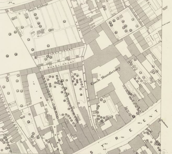
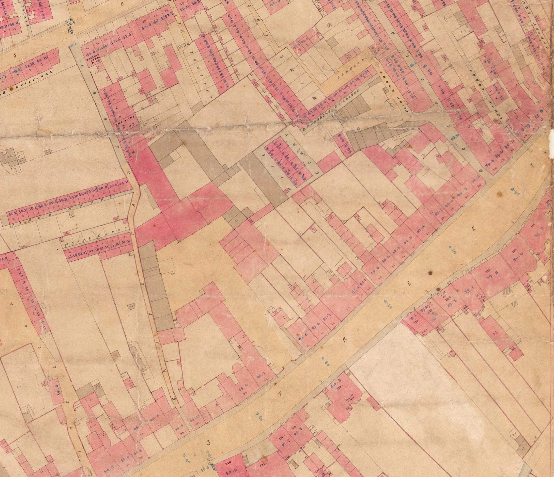
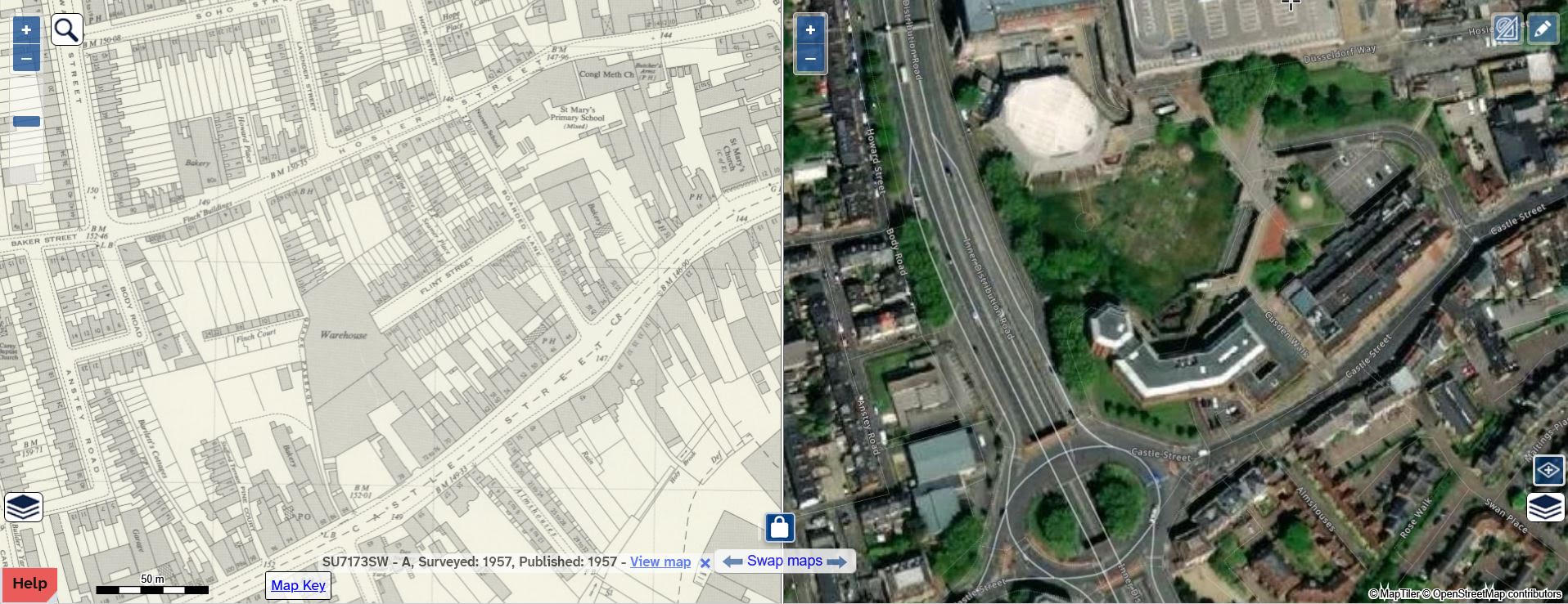
The Flint Street name is interesting and unfamiliar to most. Swathes of old streets and alleyways were swept away years back to develop the civic/mall area, and of course the IDR. The local nostalgia Facebook groups offer a few references to a Flint Street, so it must have existed in this area, although my quick searching of old maps only finds a Flint Court. The 1879 maps above – of course we’re right on the fold so there’s two images – show the Alms houses at the bottom and therefore we can pinpoint the police station site directly opposite. You have a coach manufactory and a “Grape Passage” – but perhaps I can see why they’ve not gone for that. Flint Court and Boarded Lane appear to me to be slightly further east of this site. But nevertheless, the concept of looking back for naming inspiration and of reconnecting some lost links is laudable, even if this project is by no means a resurrection of the history of its precise plot. I’m just surprised they didn’t go with the optimism of Hope Street, after another lost lane just the other side of the site.
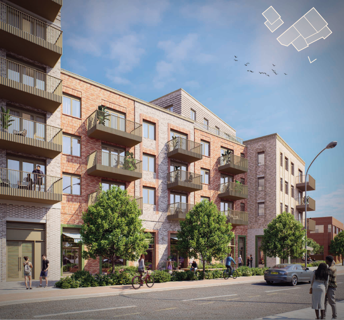
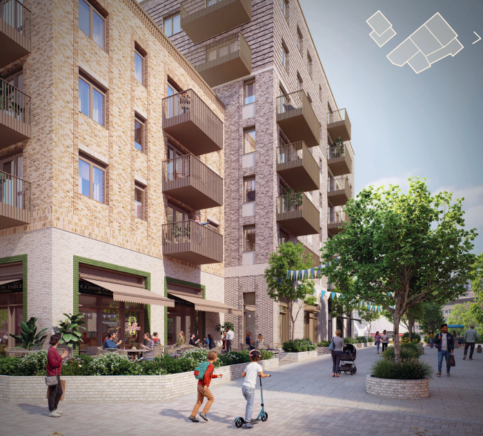
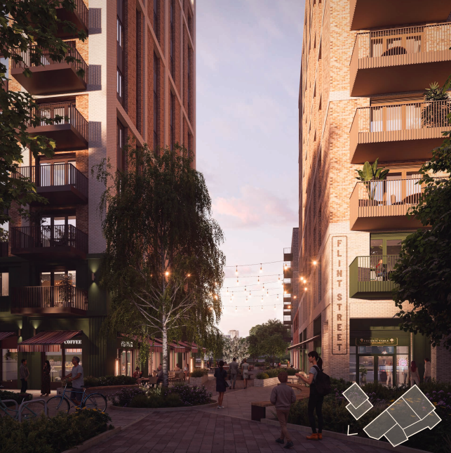
The new Flint Street will be a pedestrian link inbetween the two residential buildings making up the scheme, and should act as the natural route into the new civic area/Minster Quarter for those arriving by foot across the peril of the Castle Street roundabout. Festoon lighting and outdoor dining feature in the visuals, but the specifics of the ground floor layouts, and any occupiers, will come much further down the line. Resident facilities such as gyms and communal areas might yet be the more likely uses, but nevertheless, it looks set to be a pleasant enough thoroughfare, perhaps not too dissimilar in nature the new Friar’s Walk link within the Station Hill area.
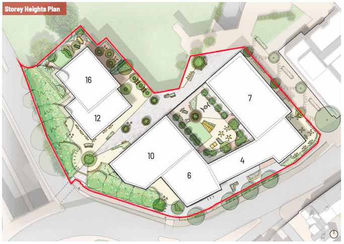
Proposed building heights vary considerably across the site – a contrast to the 11-storey monolith designs cropping up elsewhere. Here the graduation is from a mere four storeys on Castle Street, seeking to impose no further than the doomed police station on the conservation area and the view from the Alms houses, up to 16 storeys at the northern end, which is screened more heavily by the IDR and, in the future, taller buildings mooted for the civic site.
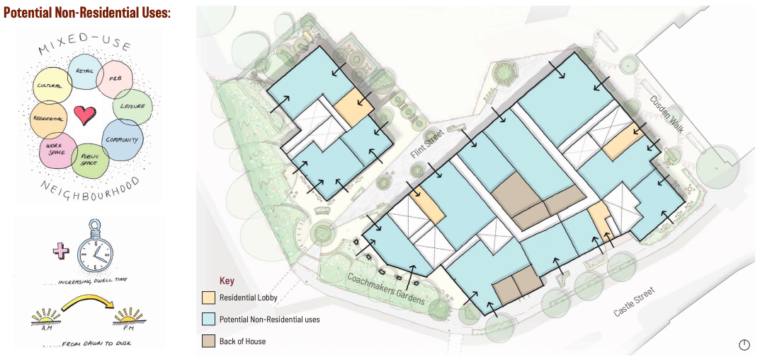
Castle Street will also have the potential for retail, community and resident facilities on the ground floor, as will Cusden Walk. No word on any possibility of the magistrates courts next door coming forward for redevelopment – that would really help enhance this “modern stretch” of Castle Street. The Police will have the option of returning to the site in the form of a small unit to act as a town centre operational hub, and there seemed to be a rumour they will do similar as an interim in one of the shopping centres until the Flint Street project lands… unless anyone knows whether that’s already happened?
The uppers floors will consist of 205 apartments, of a variety of sizes. The big appeal of the scheme for the council will be the commitment to 30% affordable housing. A prominent property consultant in town was recently quoted as saying that the current economic climate renders anything above 10% unviable. Clearly they might have a vested interest in making that case, but the number of schemes around town still stranded without the finance to proceed supports the claim that viability is a major issue, with current global events unlikely to help. Here, the developer believes they can make it work, and it will certainly be a significant boost to their chances through the planning process, with the desire for policy-compliant affordable housing quotas consistently dominating committee debate in recent years. And after the same developer had a protracted saga with planning at the Drew’s site on Caversham Road a few years ago, they’ll be wanting a smoother ride this time around.
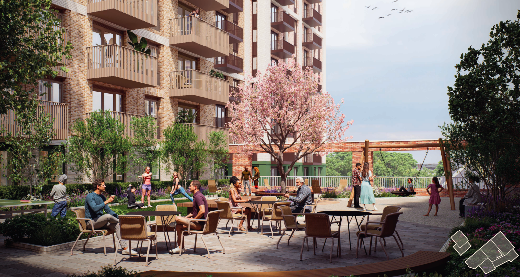
The development is presented as “net zero”. Ten trees will be retained at the western fringe, in an area termed “Coachmakers Gardens” in another nod to the past. Forty new trees are proposed in and around the site. The greenery-rich courtyard shown below is at a podium level and would be exclusive to residents.
There is a consultation website here where you can view the details for yourself. There is also a feedback feature where you can physically pin your views to the appropriate part of the plan – a new one…
My view is that we need to see this prominent site come forward, and whilst the “yet more flats” argument is always in play, we clearly need more accommodation and brownfield sites like this can help meet the demand whilst supporting a vibrant town centre. But what do you think? Have you high hopes for Flint Street, or do you think the plans for the Police Station are a crime scene? Let the developer know on the link above, or leave your thoughts below – no registration required.
Addendum:
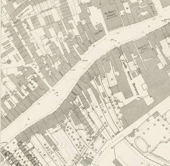
Thank you kindly to a reader for supplying this 1957 map showing Flint Street, running roughly east/west slightly behind the Police Station/magistrates site. It appears to have existed from the 1890s until at least this date. Image below:

High hopes here, I wish them luck in the planning process. Just last week I walked past the site and was immediately concerned by how bad the area looked with the temporary fencing and boarded up windows. The sooner it starts getting developed the better, I can’t really see any negatives to it personally.
LikeLiked by 1 person
Gentle density this is not. Wasted opportunity and more of the ugly same.
LikeLiked by 1 person
What are your better ideas for the site?
LikeLike
And further to Anonymous’s question about your better ideas for the site, I’ll add “What are your demand-informed, policy-compliant, and costed better ideas for the site?”
Any half-wit can trot out their fantasy wish-list (“… an ice-rink!!”).
LikeLike
We don’t need anymore flats. They could put a leisure centre with watersides for the children in this area.
LikeLiked by 1 person
No problem with more flats, higher population density in the town centre is sensible, avoids sprawl and makes local leisure more viable.
My quibble is just how square and dull all of these new apartments are. They have almost zero aesthetic merit. They’re not active ugly at least, but they’re horrendously dull. Maybe use a second tool for design, beyond a ruler?
LikeLiked by 1 person
Think you’ll find that Grape Passage was originally Grope Passage and prior to that Gropecunt Passage as it was notorious as the place where the prostitutes used to gather.
LikeLike
Looking at an OS six-inch map dated 1888-1915 there is a ‘Flint Street’ located immediately behind where the police station resides today. So it would look like the new plans effectively reinstate this road. I am unable to post an image, but this website from the national library of Scotland is a useful one for comparing old maps and aerial photographs.
https://maps.nls.uk/geo/explore/side-by-side/#zoom=5.0&lat=56.00000&lon=-4.00000&layers=1&right=ESRIWorld
Massive shame this area cant be turned into a larger live music/ performance space. With the hexagon undergoing a revamp, a complimentary facility in keeping with the hexagon theme would have been great.
LikeLiked by 1 person
Thank you for this! If you could send me the map image to readingonthames@gmail.com I can add it to the article.
Take your point on arts venues. I think we’re guilty of not quite knowing where to put further facilities. I’ve argued the sorting office site by the station would be the most accessible site for a major arena-style venue. There was an idea for a theatre on the Thames at one point (Hill’s Meadow car park) and now the Gaol is a favoured approach. But the Hexagon cluster is a good argument too.
LikeLike
It’s a fair point about uncertainty of where to place things, but I still think this a big opportunity potentially wasted. The space will be completely cleared, not something I think or would wish for regarding the Gaol, and so any facility there will be restricted in design and scope by the existing footprint. The police site would offer an opportunity to construct something original, distinctive and possibly something that might offer a bit of civic pride?
The sorting office site arguably could offer the same cleared site opportunity, but the police station also occupies a town centre(ish) location, not something that can really be said about the sorting site or Gaol. An entertainment venue of some description would mean that any potential visitors coming in by train would be forced (guided strategically) past the amenities offered in town. An increased footfall would surely bring some shared prosperity. A visitor by train heading to either the sorting office site or Gaol would have no real need to visit the town centre per se, and there are no complimentary facilities (pubs restaurants) nearby to either, unless constructed at the same time.
LikeLiked by 1 person
This is more a generic comment rather than just one about this plan. There seem to have been so many plans over the last few years that get approved but for whatever reason seem to have stalled. Whats happening to the development at the old gasholder site, or the old Royal mail site by the station. Even Station Hill seems to have stalled completely. The planning portal on the council website is fairly incomprehensible to most people, would be nice to have some clear commetary on whats actually getting built. Apologies, rant over
LikeLike