
This week I attended a consultation event for a new development proposal beside the Thames in Reading. With the Environment Agency also currently seeking feedback on their own significant scheme for flood defences in the town, which incredibly include a whole new section of river, it seems like a good time to review both projects, as well as revisit why I write Reading-on-Thames in the first place.
Dara O’Brien, Griff Rhys-Jones and Rory McGrath are messing about on the river, recreating Jerome K Jerome’s 1889 novel Three Men in a Boat. I’ve managed to dig up the TV show on YouTube, even though it’s from back in 2010. Of course, as they paddle their skiff into Reading’s stretch of the Thames the jokes start coming [4:10 in clip], echoing a typical media depiction of the town. In fairness, they largely quote from Jerome: “The river is dirty and dismal here. One does not linger in the neighbourhood of Reading.” Why is it that we’ve somehow failed to capture either the charm of the smaller towns on the river, nor the waterside architecture or cultural credentials of the capital? The second city [sic] of the Thames: we underplay our hand, and I’d like to encourage us to push the boat out.
Another aim of the blog is to encourage greater provision of leisure facilities for the town. The river provides an interesting setting to research a little history in this area. The site of the apartment scheme unveiled this week was intriguingly marked on old maps as a skating rink (we presume roller skating), although even the various retro Reading Facebook communities fail to reveal any memories of it. They do, however, recall a riverside bowling centre, The Excel, with an upstairs “River Room” club and restaurant. Thamesside Promenade boasted a model railway and a paddling pool, Christchurch meadow a putting green, and View Island, in the distant past, a hotel and tennis courts. Whilst these venues never all co-existed, and individually may have had their day, I think it’s fair to say that the role of the river is at a relatively low point in terms of leisure provision, despite the recent success of the Lido restoration.
A few year’s ago, there were proposals for a cafe, mini golf and boat hire facility on Christchurch Meadow. The ideas spawned a “Save Christchurch Meadow” alliance of near-neighbours and environmentalists. In truth, the concept had also included an unsightly metal high-ropes climbing attraction that would indeed have scarred the setting, yet the baby joined the bath water, chucked in the river and sunk ever since. We need to be a bit braver here. Henley have managed at least an ice cream kiosk without alerting UNESCO. We can show more pragmatism and provide some low-key facilities for a summer Sunday afternoon stroll by the meadow or along Thamesside Promenade. Is it even a promenade, he muses philosophically, if nobody’s walking along it?
The Henley reference is perhaps unfortunate. Whilst so many of you have kindly commented, complimented and constructively critiqued my blogs, a few seem to have interpreted Reading-on-Thames as a gentrified campaign to purge us of poor people and non-rowers. This is of course not my intention. Rugby types can stay too. Seriously, I think you can share ideas and campaign for improvements to benefit the whole community. What I would dearly like to see is a slightly more positive approach to changes in the town. I’d love to replace “No. Never” with “Yes, if…”
This week’s proposal from Berkeley for 200+ apartments on the old SSE site on Vastern Road is worthy of a big “Yes, if…”. The exhibition was very well attended and their representatives explained the consultations and revisions that have already taken place. The scheme provides a dedicated pedestrian and cycle link from the station through to the river and Christchurch bridge. The architecture has been revised from a modern glass-fronted design to a more “wharf-style” industrial yet contemporary look. Heights have been reduced, and some mews houses are included to blend into the adjacent terraced streets. However, there’s a huge disappointment: absolutely nothing to address the points I raise in this article regarding making the most of the Thames. Their own consultation website includes reference images of their project in Fulham, with a riverside dotted with tables and parasols, with cafes or restaurants behind. In Reading we have only homes. Berkeley, it’s a “yes, if…” you make some space in your scheme for places for us to stop and enjoy the setting. I know sunlight and access pose problems, but I firmly believe you can craft out a sunny riverside corner for a restaurant, and maybe a cafe and a kiosk as well. Give the place some personality. Make it somewhere we might take visitors to the town. I’m not saying bright lights and late night bars of the Oracle, or anything to compete with Caversham centre, just a couple of venues to support a steady flow of Caversham commuters, passers by and residents of the rapidly growing town centre community.

At the same time, we find some new detail emerging on plans to address flooding around the Thames. The Environment Agency has finally worked down its list of priorities following 1947 and come up with a major scheme to alleviate flood risk in Lower Caversham. I can say personally that I decided against buying my first home in the affected area due to flood risk, so to me, in a world of fluctuating climate, it’s surely great news that the government is wading in with a proper solution.
Apparently, though, I’m missing something. A campaign website has sprung up already. They’ve done that really annoying thing where they draft the angry letter of complaint on your behalf so that you can direct your ire at the authorities in the fewest number of clicks possible. They challenge the need for the scheme altogether, and criticise major elements of the design. But really it’s a “No. Never” campaign.
The scheme will have a big impact. We all know about the constraint that Reading’s bridges place on the road network, yet they actually have a similar limiting effect on the flow of water. Central to the design is a new “channel” to increase river capacity flowing through Reading bridge during floods, as an alternative to it backing up through built up areas. I would term this channel a new branch of the river, with footbridges either end to maintain access to Christchurch and Hills Meadows. New grassy embankments will alter the scenery, with a new path running along the top.
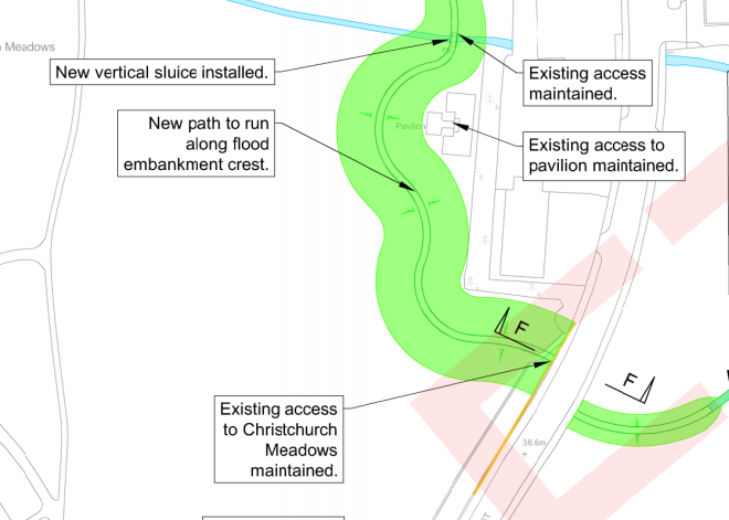
My reaction to the new river would be “yes, if” you relocate any play equipment. Yes, if you ensure the new footbridges have an attractive design. Yes, if you make sure the new “channel” becomes an asset in its own right – with nice planting, not concrete sides, maybe use it for little children’s boats for hire? Yes, if you make sure the new island created by it remains a pleasant place, maybe re-instate the putting green?! On the embankment, yes, if there’s still space for the major events like the beer festival over the summer. Yes, if you get rid of the crazy kink around the tired old pavilion and instead build a new one on the meadow side of a straight embankment. And maybe that could even house the public toilets that now seem under threat all along the river… and maybe even a cafe too?!
Of course, it’s a difficult balance. We want a riverside that’s a haven for wildlife – maybe View Island is the main place for that. We want a pleasant and quiet community facility to walk the dog and get a moment’s peace. We want sports provision. But we also want our riverside to be a well used leisure destination for Reading people and even the odd visitor, including any future Jerome K Jerome disciples. Do I think such commentators might one day be more complimentary? Resoundingly Yes… If you want them to.
The Environment Agency can be contacted via their community information page. Berkeley want your feedback on Vastern Road. You’ll have to draft your own response.
Follow @readingonthamesYour comments, as always very welcome – registration not required…

I would like to be kept informed of proposals. It’s not always easy to find up to date information.
It would be excellent to encourage greater use of leisure facilities, especially for children, encouraging wildlife exposure and fish ladders?
LikeLiked by 1 person
Agree with pretty much everything there. Went to view the plans and architect seemed a bit surprised by the suggestion of a cafe or non residential building on the river front. 11 storey blocks are too tall for that plot (note relatively low heights of Brigham Mead and other recent developments between Vastern Road and the river). It will dwarf the existing Victorian housing on Lynmouth Road and entomb the river front, rather than opening it up. I like the idea of the avenue down the middle, opening up on to Vastern Road – and the designs look okay (but still not stunning).
So, the new water channel would skirt south of the tennis courts, on what was the old putting green? Which would be no loss now as that piece of land just turns into an untended, overgrown hazard area (concealed dog mess and needles) in the summer. If it helps protect Reading and Caversham from flooding and can enhance the area, I’m all for it.
LikeLiked by 1 person
I mostly agree with you on the new housing, however the channel is not the only thing the flood scheme includes, it also has around 4 km of walls some 1.8 m high and a lot of large humps. The opposition is not to any scheme, (it is the campaign for a better flood alleviation scheme), it is to the manner that the worst case possible has been presented with a very heavy engineering solution as the only possibility. Many trees are threatened and the walls are of a largely industrial character. The scheme will cost £35 million to deliver protection from an event that has never happened and is being proposed simply because government funding is available.
LikeLike
thanks Spencer. It looked to me like the perimeter of Christchurch meadow was a combination of grassy banks and temporary removable barriers – not sure what the permanent fixings for those look like.
Looking again, it does look like stretches of wall are proposed elsewhere along the river, but I’d need to see some visualisations to form a view on those. Hopefully you can offer some feedback to improve the plans. I’m not sure it’s sensible to assume an event of the scale of 1947 couldn’t happen again.
LikeLike
You’re putting your finger on it there. The EA proposals have precious little in the way of visualisation and no mention of the effects of the scheme on people and the river environment, including trees. The channel cuts through the current playground (‘Sandy Park’), under Reading Bridge, and through about a fifth of the car park on Hills Meadow, with consequent loss of a number of mature trees on both sides of Reading Bridge. There is no indication of channel depth, and the edges will be sheet piles with concrete capping beams (Google it and weep). I agree that a constructive dialogue with the EA may yield a better scheme in due course, whatever form it will take, but it’s regrettable that the EA has not anticipated the questions that would inevitably be asked, and not provided more information from the outset, e.g. about what the scheme will actually look like on the ground and how they will mitigate for the inevitable effects it will have on the local landscape, people, wildlife and facilities.
LikeLiked by 1 person
The scheme documents are light on detail when it comes to the proposed channel. How deep will this be? Will it be dry in normal times and only come into use at times of flood? What will the bed level be? – this should have been shown on the drawing.
LikeLiked by 1 person
Perfectly happy with the new channel idea, as somebody who goes out on a boat to explore the Thames in the summer another little area of the river creates interest and it’s practical too protecting Caversham and the Town centre from future flooding. As for the housing block, as always I would rather see the site in commercial use being so close to the rail station to keep work in our town centre and continue to see more people arrive to work than leave, but the council must sell out to london and nobody wants to see any more ’empty office blocks’ posts on getReading or the Reading Forum (most I see appear to have at least one floor in use so I’m not sure what the problem is). Height wise, I would unusually like to to see the front against the river reduced in a couple of storeys but the Vastern Road side increased in the centre as I like the symmetrical central towers look, stepping down to the side street. I believe the path through the centre would be well used and if they could have a wide bridge over Vastern Road it would be even better, creating an uninterrupted walking/cycling route from the rail station to Caversham Precinct. The path should have a decent footfall for any shops, restaurants, etc.so to have these missing would be a rather daft move by the developers as these private-public spaces never live up to the idea that they breathe life into town centres, poorly designed ground floor areas in residential developments have a tendency to be rather desolate (see Chatham Place).
Cheers
LikeLiked by 1 person
Precisely RG – should be a busy and pleasant route. Do feedback!
LikeLike
I am a firm believer that the river Thames could be utilised more for public transport!
LikeLiked by 2 people
Re the flood alleviation plan – we’d be mad to pass up on a now-or-never opportunity to reduce future risk. Climate change is real and it’s only down to better management of the river (improved weirs, Jubilee flood relief scheme etc) that we have not had another 1947 scale event in Reading. The EA said River Thames water levels in the 2014 floods were at the scale as 1947. Such events are increasing in frequency. It’s an on-going battle.
This revised scheme seems to rely less on concrete wall construction and more on improved river flow. If done properly, the new channel could become an attractive feature.
The government funding is there now. Use it or lose it.
LikeLiked by 1 person
All these “ifs…” without stumping up any “£££s…”!!
Perhaps we could create a massive multimillion pounds Crowdfunders?;
Or apply for a first gov’t-funded postbrexit community grant?
But demanding this, that and t’other when the agency is broke, the unitary authority is broke and half the town’s pop. is broke, is just asking for a pile of expensive real-estate and a few trees as a sop…
LikeLike
Notify me of new comments via email.
LikeLike
Re the flood scheme: the proposed scheme is supposed to stop flooding from the river.
Whereas the 1947 flood was due to snow melt, thus the proposed flood scheme would hinder a 1947 repeat event because the walls would stop the water flowing into the thames.
Also, it is possible that putting walls up and cutting a new channel will actually speed up river flow causing more problems down stream.
I personally want the EA to provide more information on the science side to convince me why such a scheme is needed.
Finally regarding climate change: Many sources are stating climate change is actually causing a reduced amount of water to be available, so a extreme flood event with increased peak water levels which this scheme aims to prevent may not happen.
LikeLike
I’m not an expert in flooding – you may have valid points here and I agree on the need for the science to be explained to us. I’m sure I have read that 1947 was partly due to heavy rain running off frozen ground rather than soaking in. The amount of concrete and tarmac laid in the intervening period might create a similar effect? But agree with your call for further explanation of their models.
LikeLike
I’m not an expert either. I’m uneasy about the consultation documents, which consist mainly of drawings but which, as pointed out by other commentators above, do not explain how the proposed scheme will work. In particular, how it will work without exporting the problem downstream.
LikeLike
10th April Briefing to Reading Civic Society from the Berkeley Homes team yesterday – they are meeting local groups again on their 3rd round of Engagement.
Sgnificant changes to the design and layout, especially to the buildings on Vastern Road which now have a single look in Reading Red brick with some stepping back from the pavement and greening. Deeper window recesses, larger balconies – more wharf like. Wider assembly point at the exit on Vastern Rd. Heights vary 3 storey (Link element) to 6 to 11.
On the Riverside significant changes. Yellow Bath / London brick. buildings stepped back more with more greening with almost a small (spaces on the site are not big to start with) plaza. Link building removed and a building turned so more units have riverside views. More open views when coming over Christchurch bridge – which will land within the site. Plan includes small café as that idea came up several times. Looking to remove the brick wall which divides the site from the pathway along the Thames – replace with something more pervious. Far more greeing of this area.
Number of mews houses now 6, reduced by two – to address light issues. Height at the back reduced to single storey to address concerns from neighbours. Small gardens added.
Locally Listed Building – they have tested and tested the options but just do not think they can incorporate this building. This will be a discussion clearly with the council and will have to be a balance of the loss against the benefits.
Mixing Cyclists and pedestrians – wanting to avoid putting up barriers … hoping that mixing will slow cyclists down.
Overall number of units reduced from initial 240 to public exhibition of 197 now 185. Parking spaces increased from 47 to 67 takes account of Verto experience of not providing enough spaces.
Examining with RBC placing of crossing point across Vastern Road – there are already 3 crossing points – council would not want another.
Public Exhibition planned 10th May. A formal Planning Application is expected to follow in June.
LikeLiked by 2 people
That sounds very promising Richard. Thank you for sharing.
LikeLike
The next public exhibition about the future of the SSE Site is being held on Wednesday 8th May 2019 between 3.30pm and 7.30pm at the SSE site, 53-55 Vastern Road, Reading
LikeLiked by 1 person
I visited the exhibition in May and thought the developers had made some notable improvements – in particular, making the thoroughfare more readable, more wharf-like blocks and adding a small plaza with the possibility of a cafe.
As a resident of the Caversham Road area I remain unconvinced that the proposed flood defences will be effective. I challenged EA staff at one of their exhibitions to explain how my area would benefit given that we know that floodwater comes in under our floors following the height of the Thames precisely (I saw this myself in 2003 and 2014) and they quickly tried to change the subject, stating that further investigation would be needed. I can’t see any flood walls preventing that – our area would effectively lose a lot of its connection to the river for no clear benefit.
LikeLiked by 1 person